26th September 2011
Once again we drove into Atherton to the Post Office and this time we were lucky and able to collect the long awaited parcel, which as it turns out had been available since 5 days earlier but because merry had enquired after a parcel in the name of Line she was told there was nothing. It had been sent to the post office without our name on it and it was only because Merry said it was a parcel and then able to state the name and address of the sender that was written on it that they agreed to give it to us. We then went on to Mareeba to check out the various museums and on arrival Merry elected not to do the heritage museum as we will be doing the Herberton Village soon so we moved on to the military museum. This supposedly is the largest privately own collection in Queensland, which it very well could be, but it is also the worst laid out museum we have come across. It is a huge collection but most of it is in very shabby condition and crammed together so that it is impossible to look inside anything or to take a photograph of any one item. Because of the huge open ended hangar that the display is in, the photos are always backlit which doesn’t help. The display also included aircraft such a Canberra bomber and a twin tailed Vampire which Barry used to watch at his local airfield in West Malling when he was a kid. Again, photos without other clutter under the wings were impossible, and it was also impossible to get far enough away to get all of the individual aircraft in the frame because of the limited room to move, even on wide angle. We didn’t stay too long as it was a case of walking along the pathways and out again. We moved on down the road to the Aviation museum which had been closed on our last trip to Mareeba, and was still closed, so we headed home after a disappointing museum exercise but pleased with the collection of our parcel. We probably will not bother visiting anymore aviation museums as we have seen the Perth and Darwin Aviation Museums which are both excellent, and therefore can stop being disappointed with other inferior ones.
27th September 2011
Generally a lazy day but we did drive out to Hastie’s swamp, about a 15 minute drive, to watch the birdlife at sun set. In particular, we were hoping to watch Sarus Cranes come in to land for the night, and were rewarded at about 6.00pm when quite a few groups came in with an overhead fly past and then circle round on a landing run.
 Unfortunately they prefer to land on the far side of the swamp so all photograph is long distance and not real good for full zoom with a moving object. The overhead shots tend to be silhouettes against the sky and the landing shots have a dark tree background, however we did achieve a few acceptable shots considering the lack of light.
28th September 2011
We had to go into Atherton once again to return our outside TV as its power pack has died, but unfortunately it meant returning the whole lot to the agents in Cairns, meaning it would take about six weeks at best. As we were not planning on being at our current location for that long we elected to take it to Cairns ourselves and try to simply get them to order a new power pack, and then post it to us.
 The good news is that on the way into Atherton we spied some Sarus Cranes in one of the local fields and were able to get some slightly closer shots.
 In the afternoon we drove out to Tinaroo Falls Dam and found more cranes on the way and then found that there are no falls as such, and that it is just the name of the small village on the edge of the lake and fairly close to the Dam wall.
There is a section of the wall that would resemble a waterfall if the lake level was a lot higher to pour over the weir but this is near the end of the dry season and rain still some way away. Also there is an outlet from the dam which is feeding irrigation channels to the cane fields which is permanently lowering the level. We continued on to over the dry river because of the lack of water over the weir and past the dam wall on the other side and continued until the road became a dirt road to several camp grounds for boat fanatics and fishermen. We stopped at one point that claimed a 20 minute Lake walk which only took us 10 minutes and only had glimpses of a lake and then expected to eventually meet a dead end and have to return the way we came.
 That didn’t happen as it joined a bitumen road that took us to a carpark to the Cathedral Fig Tree which is in opposition to the Curtain Fig Tree, but we preferred the Cathedral Fig as the winner although both are quite amazing. The road eventually joined the Main road into Yungaburra and back to our base.
29th September 2011
We took the TV into Cairns via the Gillies Highway which passes through the Gillies Range and down off the Tablelands back to sea level, about 1200ft, which is a very tightly winding road for about 20kms with great views if you dare to look out over the severe drop off the side. Going down meant we were on the inside of the road which creates the slightly saver feeling but still hair raising, especially knowing that you will be on the outside coming back up. Cairns is bigger and busier than we expected and the traffic became more frantic with little regard for red lights. After sorting out the TV problem, ordering a new power pack for posting to us, we found a Jaycar agent and bought some cable, an appropriate plug, a soldering and solder. This is to allow Barry to make up a cable to join the 12v outlet on the outside of the caravan to power the TV from the vans battery, which means the new power pack will be put into storage when we get it. After also shopping in Cairns Central we drove to the beachfront, and along it for some considerable distance, looking for a parking spot with eventual luck and stopped for lunch. This was followed by a trip to the Botanic Gardens to find it a ‘No dog” area so gave Cairns the flick and drove up to the Tablelands with a couple of stops to admire the view, although this was rather hazy, which according to the TV news was the result of smoke from fires near Mareeba. On arrival back at the van Barry made up the cable for the TV which allows us to use the TV without the power pack.
1st October 2011
We started out early to Millaa Millaa to do the waterfall circuit taking in Millaa Millaa Falls, Zillia Falls and Ellinjaa Falls and then continued along the Palmerston Highway to Mungalli Falls.

 Some used a viewing platform but others allowed access to the base of the falls which involved winding our way down 80 metres and obviously back up so we gained a good workout on several occasions. We continued on to Henrietta Creek which offered several ‘No Dog’ walks but we used the park benches for our picnic lunch anyway before continuing to another group of falls.

 The first being Nandroya Falls but this was a ‘no Dog’ deal with a long walk involved and the time required for the walk was way too long to leave Foxy in the car with a 30°C plus temperature.
We continued on to look for Crawford’s Lookout but didn’t find initially but we did on the way back and then stopped off at the entrance to Wallacha Falls and Tchupala Falls which used a common start point but splits two ways, and we chose the longer way to go first to Wallicha Falls.

 On the way back we turned off to Tchupala falls and found the final section of the path closed off due to cyclone damage (2 years ago) that hasn’t been repaired yet and stopped us going down to the base of the falls, but allowed a no-so-good view of the Falls part way down. Our run on waterfalls was over for today but detoured to Millaa Millaa Lookout which was good, but slightly spoilt by the smoke in the air from the fires that has been in the Tableland area for several days. After arriving home we had a short rest and then walk across to the side of the local Lake Tinaroo and photographed the sunset. There are several more waterfalls to explore but due to the ‘No dog’ regulations anywhere close to something of interest, we will leave Foxy at home for the next trip.

 Some used a viewing platform but others allowed access to the base of the falls which involved winding our way down 80 metres and obviously back up so we gained a good workout on several occasions. We continued on to Henrietta Creek which offered several ‘No Dog’ walks but we used the park benches for our picnic lunch anyway before continuing to another group of falls.
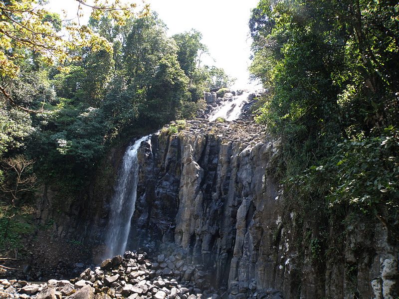
 The first being Nandroya Falls but this was a ‘no Dog’ deal with a long walk involved and the time required for the walk was way too long to leave Foxy in the car with a 30°C plus temperature.
 We continued on to look for Crawford’s Lookout but didn’t find initially but we did on the way back and then stopped off at the entrance to Wallacha Falls and Tchupala Falls which used a common start point but splits two ways, and we chose the longer way to go first to Wallicha Falls.

 On the way back we turned off to Tchupala falls and found the final section of the path closed off due to cyclone damage (2 years ago) that hasn’t been repaired yet and stopped us going down to the base of the falls, but allowed a no-so-good view of the Falls part way down. Our run on waterfalls was over for today but detoured to Millaa Millaa Lookout which was good, but slightly spoilt by the smoke in the air from the fires that has been in the Tableland area for several days. After arriving home we had a short rest and then walk across to the side of the local Lake Tinaroo and photographed the sunset. There are several more waterfalls to explore but due to the ‘No dog’ regulations anywhere close to something of interest, we will leave Foxy at home for the next trip.
2nd October 2011
This was to be a rest day but Val and Barry (2) asked us along to the Ravenshoe heritage train trip and as we also wanted to visit the Millstream Falls in that area we agreed.
 The train trip in its own right was somewhat disappointing for us as it had no photographic opportunities of views along the way or at the destination, where we had a Lamington and cuppa. The were occasional patches of trees that had clusters of Teddy Bears and other fluffy toys tied into them to entertain the little rug rats, but nothing else of note. The return trip obviously was the same but as it was only 4.00pm we still had time to check out Millstream Falls, however, Merry’s navigational skills took us towards Little Millstream Falls along Tully Falls road. Somehow we missed the sign to Little Millstream Falls and continued for 20kms and arrived at Tully Gorge Lookout, which is also the lookout for Tully Falls. Unfortunately we are at the tail end of the dry season and because the water that would normally fall into the Gorge has been diverted to a Dam servicing a power station, the falls requires a serious rainfall to become a waterfall again..

The 293 metre deep Gorge view was great with the obvious signs of where the waterfall would be when sufficient rain happens. On the return to Ravenshoe we spotted the turn off to the Little Millstream falls and as it was only a short distance away we gave it a go. The falls are viewable from the pathway down giving a good overall view from top to bottom.

 It turned out to be the best of the falls that we have visited in the Tablelands so far, with multiple water entries, and because of the diversion to the gorge we had arrived at a time when the sun was setting right behind the falls, creating a great photo shot opportunity.

The Millstream Falls (the widest falls in Australia) which were the original destination will have to wait for another trip.
 The train trip in its own right was somewhat disappointing for us as it had no photographic opportunities of views along the way or at the destination, where we had a Lamington and cuppa. The were occasional patches of trees that had clusters of Teddy Bears and other fluffy toys tied into them to entertain the little rug rats, but nothing else of note. The return trip obviously was the same but as it was only 4.00pm we still had time to check out Millstream Falls, however, Merry’s navigational skills took us towards Little Millstream Falls along Tully Falls road. Somehow we missed the sign to Little Millstream Falls and continued for 20kms and arrived at Tully Gorge Lookout, which is also the lookout for Tully Falls. Unfortunately we are at the tail end of the dry season and because the water that would normally fall into the Gorge has been diverted to a Dam servicing a power station, the falls requires a serious rainfall to become a waterfall again..
The 293 metre deep Gorge view was great with the obvious signs of where the waterfall would be when sufficient rain happens. On the return to Ravenshoe we spotted the turn off to the Little Millstream falls and as it was only a short distance away we gave it a go. The falls are viewable from the pathway down giving a good overall view from top to bottom.

 It turned out to be the best of the falls that we have visited in the Tablelands so far, with multiple water entries, and because of the diversion to the gorge we had arrived at a time when the sun was setting right behind the falls, creating a great photo shot opportunity.
The Millstream Falls (the widest falls in Australia) which were the original destination will have to wait for another trip.

No comments:
Post a Comment